Trail Walking Le Béage - Tour de ouf du Montfol - Le Béage - Photo

Tour de ouf du Montfol - Le Béage

 tracegps
tracegps

User

© OpenStreetMap contributors
Length
Length
12 km
Max alt
Max alt
1481 m
Uphill gradient
Uphill gradient
368 m
Km-Effort
Km-Effort  
16.9 km
Min alt
Min alt
1183 m
Downhill gradient
Downhill gradient
365 m
Boucle
Boucle
Yes
Creation date :
2014-12-10 00:00:00.0
Updated on :
2014-12-10 00:00:00.0

(0 Reviews)

Walking
Walking
3h30
Difficulty : Difficult

Scan this QR Code to open this trail in the SityTrail application

FREE GPS app for hiking

Logo SityTrail SityTrail

IGN / Geographical institutes

Download SityTrail from the App Store Download SityTrail from Google Play

Logo SityTrail SityTrail World

The world is yours!

Download SityTrail from the App Store Download SityTrail from Google Play Download SityTrail on Huawei AppGallery

About

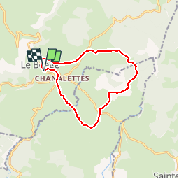
Trail Walking of 12 km to be discovered at Auvergne-Rhône-Alpes, Ardèche, Le Béage. This trail is proposed by tracegps.

Description

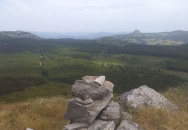
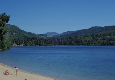
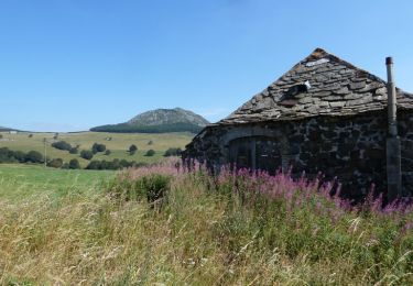
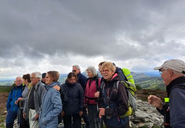
Splendide parcours en pleine nature autour du Suc de Montfol. Départ dans le village du Béage par le Gr de la Montagne Ardéchoise. On s'élève au travers des prairies et des troupeaux qui vous admirent au passage. On peut tenter l'ascension du suc à travers les rochers et les genêts par le côté sud : la vue y est magnifique. Calme et senteurs garantis !

Elevation profile

Photos

Positioning

Country:
France
Region :
Auvergne-Rhône-Alpes
Department/Province :
Ardèche
Municipality :
Le Béage
Location:
Unknown
Start:(UTM)
588671 ; 4966468 (31T) N.

Trails nearby

Trail Walking Le Lac-d'Issarlès - Grand tour lac d'Issarlès - Photo
Walking
GUIDE
nadinebondoux

Walking

Medium
Le Lac-d'Issarlès, Auvergne-Rhône-Alpes, Ardèche, France
10.3 km | 15.5 km-effort
3h 37min
Yes
Trail Walking Cros-de-Géorand - 2023-01-26_11h39m18_Le Béage-Tour des Sucs 15km.gpx.xml - Photo
Walking
chancha

Walking

Difficult
Cros-de-Géorand, Auvergne-Rhône-Alpes, Ardèche, France
15.2 km | 23 km-effort
5h 8min
Yes
Trail Walking Le Béage - suc du montfol et lauzière - Photo
Walking
nadd73

Walking

Easy
Le Béage, Auvergne-Rhône-Alpes, Ardèche, France
10.9 km | 16 km-effort
2h 32min
Yes
Trail On foot Le Lac-d'Issarlès - Le tour du Lac - Photo
On foot
PRO

On foot

Easy
Le Lac-d'Issarlès, Auvergne-Rhône-Alpes, Ardèche, France
3.6 km | 4.6 km-effort
1h 2min
Yes
Trail Walking Borée - bonnefoy les sucs - Photo
Walking
07es18

Walking

Medium
(1)
Borée, Auvergne-Rhône-Alpes, Ardèche, France
13.4 km | 0 m-effort
4h 20min
Yes
Trail Mountain bike Le Béage - Par les Sucs de Montfol et de la Lauzière - Le Béage - Photo
Mountain bike
tracegps

Mountain bike

Difficult
Le Béage, Auvergne-Rhône-Alpes, Ardèche, France
19.5 km | 27 km-effort
3h 0min
Yes
Trail Walking Le Béage - Par les Sucs de Montfol et de la Lauzière - Le Béage - Photo
Walking
tracegps

Walking

Difficult
Le Béage, Auvergne-Rhône-Alpes, Ardèche, France
19.5 km | 27 km-effort
5h 30min
Yes
Trail Walking Le Béage - les estables - Photo
Walking
Erick Marteau

Walking

Very difficult
Le Béage, Auvergne-Rhône-Alpes, Ardèche, France
19.3 km | 26 km-effort
3h 44min
No
Trail Walking Cros-de-Géorand - SityTrail - Par les Sucs de Montfol et de la Lauzière - Le Béage - Photo
Walking
GUIDE
thonyc

Walking

Difficult
Cros-de-Géorand, Auvergne-Rhône-Alpes, Ardèche, France
15.2 km | 23 km-effort
6h 0min
Yes


Close
My subscriptions